Radar data and the Silver Lining Tours incident 5/28/19 south of Lawrence, Kansas
Originally published on davieswx.blogspot.com ↗
Roger Hill and Silver Lining Tours (SLT) have been getting a bunch of heat on social and other media for two of their tour vans getting rolled during last Tuesday’s tornadic storm south of Lawrence (see my post about the weather setting here).
I’m certainly no radar expert, but based on radar data I went through carefully on Saturday, I do think everyone needs to chill a bit before passing judgement about Roger and the tour group being “too close”.
A discussion on Storm Track forum has been looking at the early stage of the Lawrence tornado’s track via Topeka (TWX) radar, and there was definitely some complex evolution going on with the storm. This data does suggest that the main tornado was developing a couple miles to the north of SLT’s position around the time they were struck by strong winds or some sort of 2nd rain-wrapped circulation coming up from the southwest in an unusual location, which matches statements by Roger.
I also looked at radar data saved from the Kansas City radar (EAX, a little farther away), and can make out two separate circulations at 6:00 pm CDT in the storm-relative velocity field:
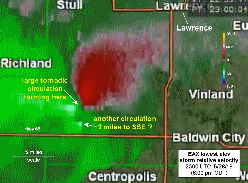
This was just before the large tornado developed at 6:05 pm CDT, with the 2nd smaller circulation visible closer to Highway 56. This 2nd circulation was located about 2 miles (check the scale on the graphic) to the south or south-southeast of the developing large tornado.
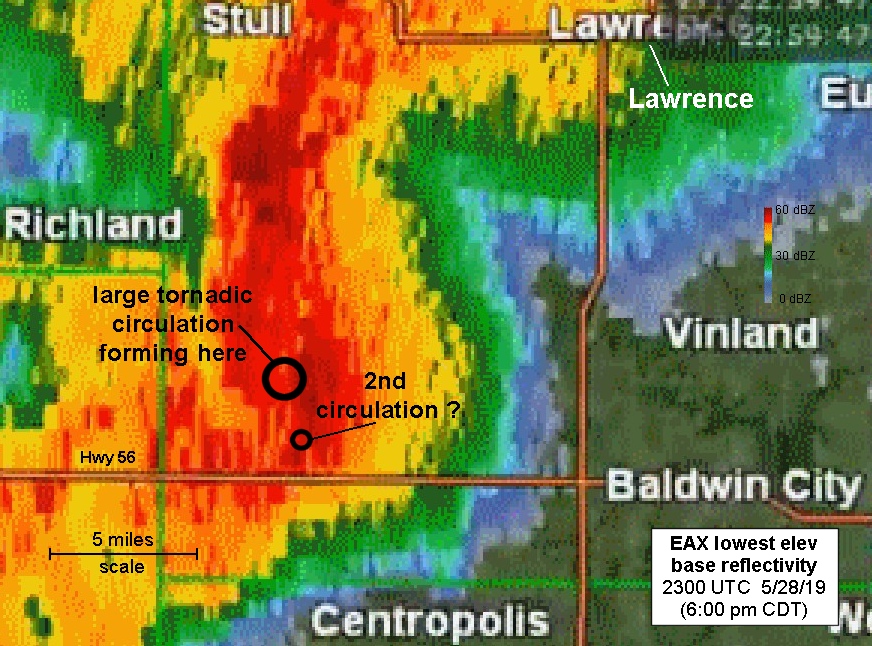
Base reflectivity at the same time (below) showed the large developing tornado circulation to be within some rain, with the 2nd circulation located southward within the wet rear flank downdraft (RFD) that was beginning to surge east with this large HP supercell:
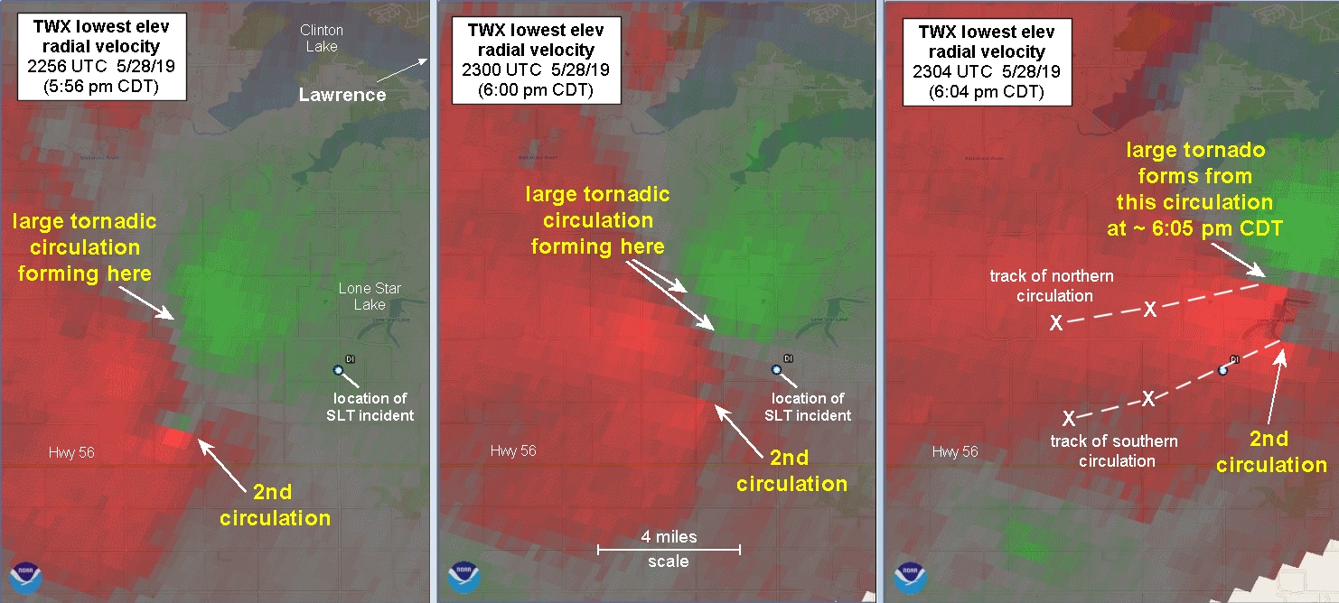
Discussion on Storm Track has highlighted this additional circulation to the south of the axis along which the large tornado formed, based on radar images and other information. Here are radial velocity images from TWX (courtesy of Jeff Snyder on Storm Track) at 5:56 pm, 6:00 pm, and 6:04 pm CDT. I’ve marked the locations and tracks of the two circulations. Notice that it appears the southern circulation moved right over the location where the SLT incident occurred, which lends credence to Roger’s description of the incident (click on the image to view it larger):
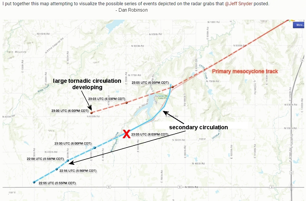
Dan Robinson on Storm Track put together a graphic suggesting the evolution of the two circulations discussed above. Here it is, a rather complex evolution prior to the start of the large tornado, with a red “X” marking SLT’s location:
Quincy Vagell was shooting video at about 6:00 pm CDT from near the location of the SLT incident,
looking toward the north-northwest:
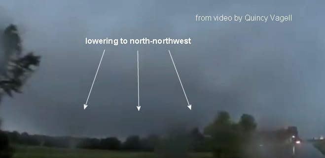
Notice the lowering visible to the northwest (in spite of rain), which is probably the developing circulation and feature that spawned the large tornado at 6:05 pm, matching what Roger and SLT say they were watching from the southeast.
Quincy describes on Storm Track a “bluish” rain curtain that was moving up from the southwest behind him and to his left. This was probably the wet RFD containing the small embedded circulation closer to Highway 56 that was not visible, and may have been what hit SLT.
To give some scale and context, I’ll mention that my wife Shawna and I watched last year’s Tescott, Kansas EF3 tornado on May 1, 2018 (a “classic” non-HP supercell) develop from a distance of about 2 miles to our northwest and north:
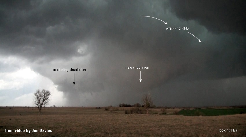
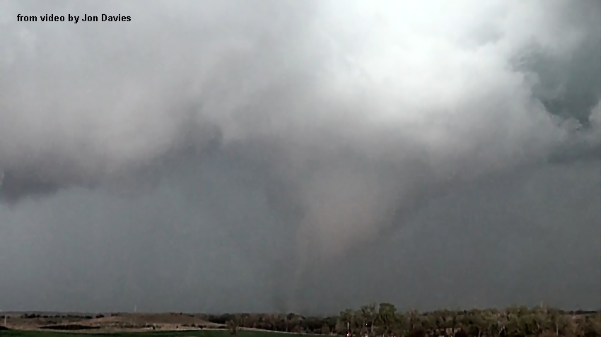
This was a similar distance and position to what Roger and SLT had on 5/28 relative to the lowering that they could see to their northwest, which appeared to spawn the large Lawrence tornado a few minutes later. But, with the wet RFD curtain coming up from the southwest, there was no way to see the 2nd circulation coming with it (from an unusual location within the storm) as they drove back south toward Highway 56 in order to head east and follow the storm from what they thought was a safe distance.
As I mentioned in my prior post, my wife Shawna and I got caught in a somewhat similar surprise situation (strong surging wet RFD winds from the southwest, south of a large tornado) with the El Reno storm in 2013, even though I have years of experience chasing storms as a meteorologist. Luckily, we managed to drive out of the RFD winds without incident.
I think what has sparked accusations of being “too close” in this situation is the characterization of the 2nd / southern circulation shown in the radar images above as a “satellite” tornado, something that implies being really close to a larger tornado. In fact, this 2nd circulation was separated from the developing main tornadic circulation by at least 2 miles or more, until it moved toward the developing large tornado after striking SLT. As such, it seems part of a complex evolution that gave birth to the tornado, and not a true “satellite” tornado.
I talked to Roger briefly on Saturday, and know that he is very shaken and more than a little confused by the evolution of what happened last Tuesday. I think we should all give him the benefit of the doubt on this event.
He and I also talked about swearing off HP storms in the future… they often surprise and do the dangerously unexpected.
Looking at the bigger picture, maybe spotter and chaser training should start focusing more on large HP storms as a special case with elevated dangers, emphasizing the possibility of wet RFD surges and dangerous winds as an additional hazard south and some distance away from a rain-wrapped tornado. And, maybe training should teach and emphasize, for safety’s sake, that spotters and chasers give large HP storms a much wider berth than what would seem necessary with storms that are more “classic” in nature. Large tornadic HP supercells are complex and visually challenging, even for experienced spotters and chasers.
Shawna and I are incredibly glad this did not turn out to be another deadly situation, and that everyone with SLT survived. That’s what’s most important. Just my two cents worth…
- Jon Davies 6/2/19