27 April 2011: An extraordinary environment for tornadoes.
Originally published on davieswx.blogspot.com ↗
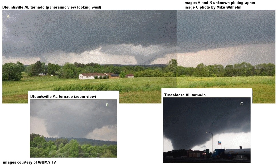
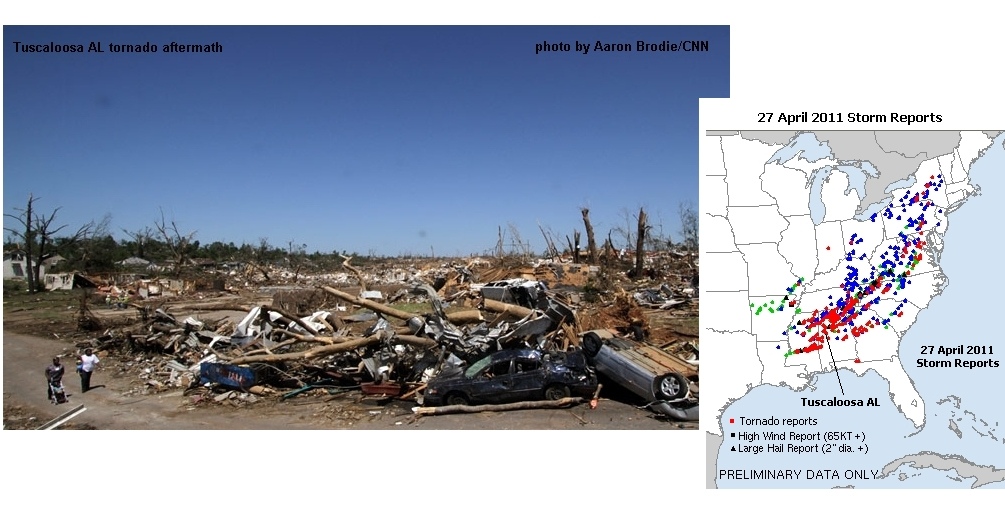
Last Wednesday’s tragic and historic tornado outbreak (see photos above, and my prior blog post) was unprecedented in the past 75 years of U.S. history, topping even the 1974 “Super Outbreak.” The number of deaths are now close to 340 people. It will take a while to sort out the actual number of tornadoes, with NWS surveys ongoing. At least one tornado has been rated EF5 so far (Sunday a.m. 5/1/11).
Why were the tornadoes so strong, so numerous, and on the ground so long? Comparing the 27 April 2011 storm environment to years of tornado database parameters that I’ve kept, the setting for Wednesday’s tornadoes was rare and quite extraordinary.
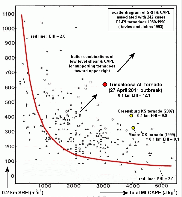
The scatterdiagram (3rd graphic above) is from research I did with Bob Johns in the early 1990s (Bob is now retired from SPC). We looked at observed soundings associated with 242 F2-F5 tornadoes from the 1980s, and found combinations of storm-relative helicity (SRH, a new parameter at the time that quantitized low-level shear, developed by Robert Davies-Jones at NSSL) and CAPE to be useful in assessing environments with potential for significant tornadoes. Using that data, and with the help of John Hart at SPC, we came up with a parameter called the Energy-Helicity Index (EHI) using the diagram above. EHI is still widely used in tornado forecasting today to assess areas and combinations of SRH and CAPE that can support low-level mesocyclones and, hence, supercell tornadoes.
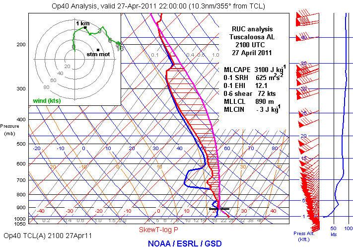
For reference, on this same diagram above, I’ve plotted the estimated SRH/CAPE combination points for the deadly 1999 Moore OK and 2007 Greensburg KS tornadoes. I’ve also plotted the SRH/CAPE environment corresponding to last Wednesday’s violent Tuscaloosa AL tornado that killed nearly 40 people (also see the skewT diagram above).
The Tuscaloosa environment location (large red dot) on the scatterdiagram is quite remarkable! It falls in the center and slightly toward the upper right in the area of most optimum SRH/CAPE combinations for tornadoes. Most telling, there are no points on the diagram to the upper right of the Tuscaloosa point, which makes it rather unique. I’ve looked through my own databases of tornado cases over the past decade, and can’t find any tornado environment that even approaches this one (roughly 600 m2/s2 0-1 km SRH _and_ 3000 J/kg MLCAPE). Typically, if SRH is greater than 500, CAPE is less than 2000 (still a very good environment for tornadoes), or, if CAPE is greater than 3000, SRH is only around 200-300 (yet another very good environment for tornadoes). To have both the SRH and CAPE so large, during daytime heating no less (SRH values are usually largest at night with the low-level jet, when CAPE is not so strong), is quite rare and unusual.
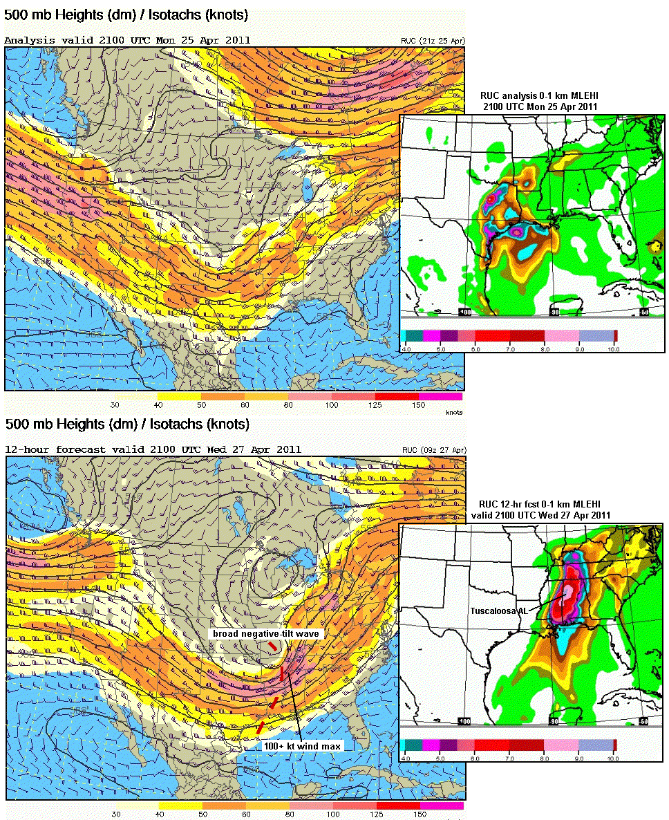
Given this information, and the fact that mid-level/500 mb winds were approaching 100 kts on Wedensday (excellent deep-layer shear in addition to low-level wind shear), it is no wonder that tornadoes were strong to violent and on the ground so long. The environment conditions where the storms formed and propagated were probably as optimum as we will ever see!
The final graphic above shows 500 mb maps and 0-1 km EHI conditions approximated/forecast from the RUC model for Monday 4/25/11 (a notable tornado day in TX and AR) and Wednesday 4/27/11 (the historic outbreak). Notice how the midlevel trough stayed in place over the southern U.S. over several days (there were tornado episodes in the South from Sunday 4/24 through 4/27), with the strongest winds peaking on Wednesday (> 100 kts) in association with a strong negative tilt shortwave moving through the trough. Notice, too, from the EHI panels, how much SRH and CAPE were present already on 4/25, setting the stage for the peak combinations on 4/27 with the strong short wave and wind max moving through. The forecast EHI values on Wednesday p.m. 4/27/11 were very large over the MS/AL area, signaling the outbreak to come, though no one could know how historically deadly it would be.
Even with the huge death toll, it must be said again that the National Weather Service and local media did a superior job on Wednesday with outlooks, alerts, and warnings. My heart truly goes out to those who have had their lives destroyed by these tornadoes. I hope anyone reading this will at least consider making a donation to help. See: www.cnn.com/impact.
- Jon Davies 5/1/11