April 9 tornadoes in NW Iowa: Contrasting daytime/nighttime environments?
Originally published on davieswx.blogspot.com ↗
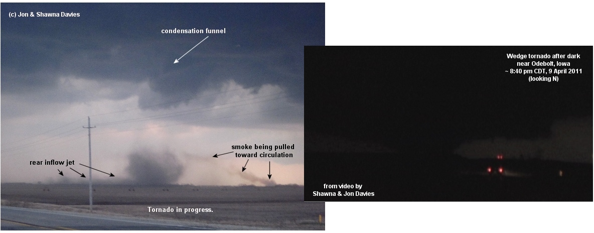
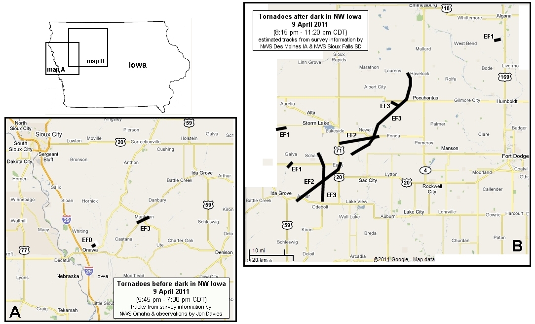
Last Saturday’s tornadoes in northwest Iowa with a persistent supercell complex over a period of several hours were quite interesting. The town of Mapleton took a direct hit before dark with a large dusty EF3 tornado developing from a rather high cloud base after 7 pm CDT (thankfully, there were no deaths or life-threatening injuries). Then, after a “break” of about an hour, the same supercell reorganized and began producing several large long track tornadoes during a 2-3 hour period after dark (see nighttime video shot above of wedge tornado near Odebolt, from Shawna’s and my storm chase that night). It is very fortunate that none of these tornadoes after dark hit towns such as Sac City or Pocahontas directly (see tornado track maps above).
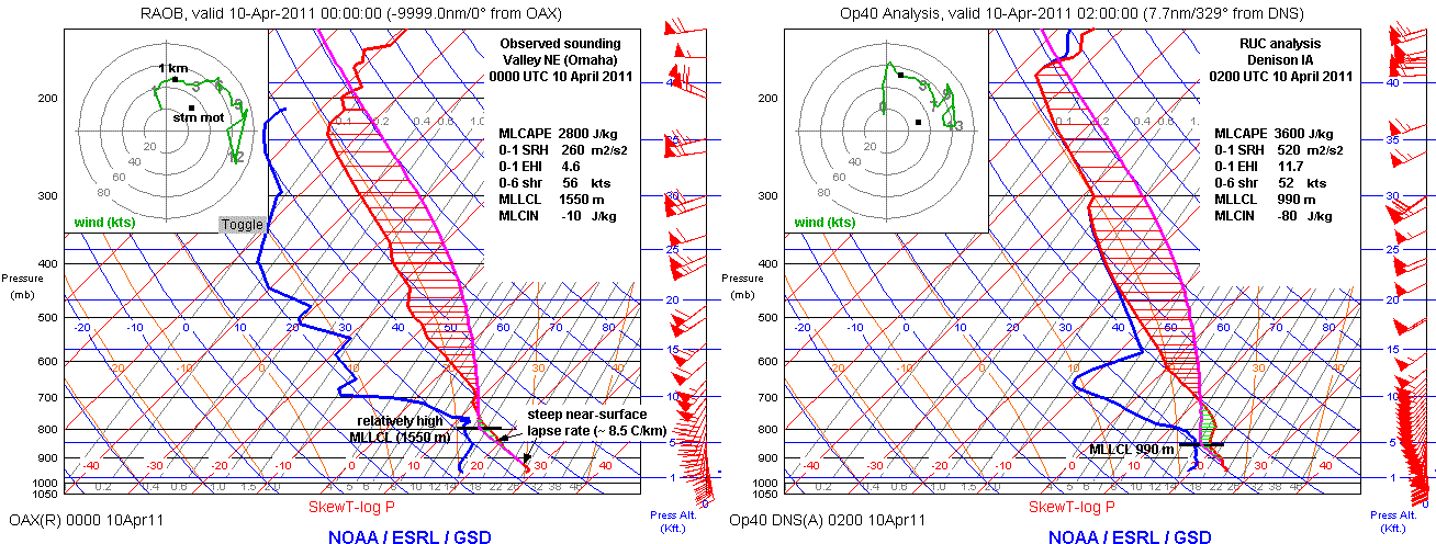
The first weak dust whirl tornado near Onawa around 6:50 pm CDT (see photo above, a “tornado” because it occurred within a mesocyclone both on radar and visually ahead of an RFD, under a condensation funnel at cloud base) was a precursor to the tornado from the same supercell that hit Mapleton about 30 minutes later. The environment at that point had relatively high MLLCL heights (around 1500 m), with an 83/61 F surface ob at Onawa, and a fairly steep low-level lapse rate (approaching dry-adiabatic, see the 00 UTC Omaha observed sounding above) with little MLCIN. The later Mapleton tornado was mainly visible due to thick swirling dust rising from the ground into a wedge shape under a similarly “high” cloud base.
The tornadoes after dark were associated with a somewhat different environment (see 02 UTC Denison IA RUC analysis profile above). Low-level lapse rates were no longer steep, and MLLCL heights had lowered to below 1000 m with diurnal cooling while MLCIN of 50-100 J/kg had built in. However, the low-level jet had intensified to around 60 kts just after dark, at least doubling the 0-1 km SRH present before dark; according to my colleague Andy Fischer, VAD wind profiles from the NWS Des Moines radar suggested that 0-1 SRH feeding the NW Iowa supercell complex may have actually been greater than 700 m2/s2! Additionally, MLCAPE increased (opposing the typical diurnal trend) as moist advection via the low-level jet caused surface dew points to rise 2-3 deg F. The resulting strong CAPE/SRH combinations (0-1 km EHI > 10) along with large deep layer shear (> 50 kts) probably helped updrafts and low-level mesocyclones overcome increased near-surface MLCIN to support significant tornado potential after dark. This environment matched those ingredients typically associated with tornadoes after dark in the Plains, as discussed in Davies and Fischer (2009).
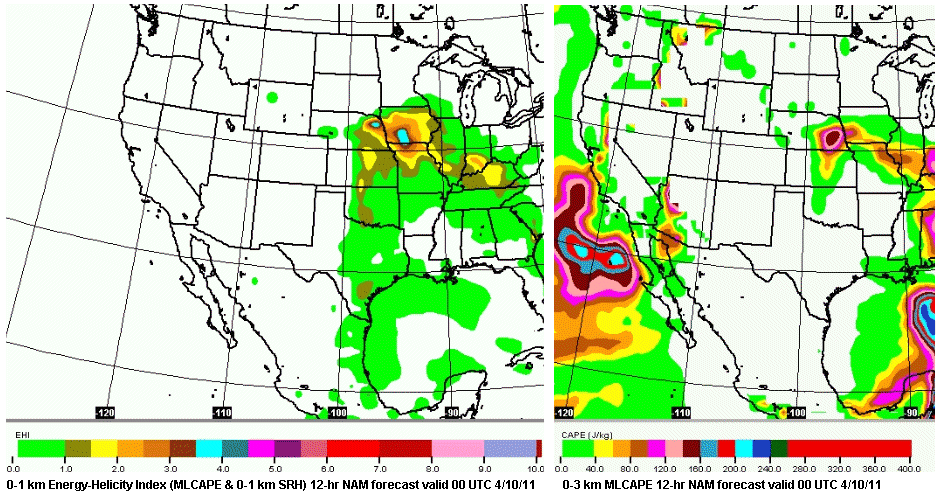
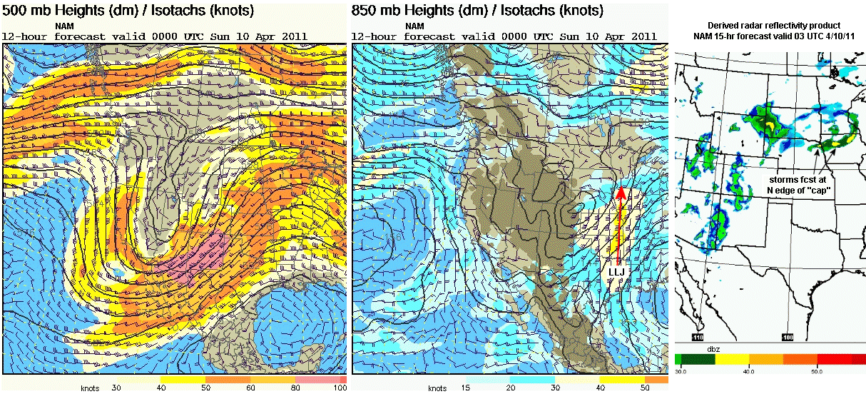
Forecast-wise, this day stood out for 2-3 days ahead of time with consistent model forecasts of strong CAPE and SRH values (see NAM 0-1 km EHI forecast above) coinciding with an area of low-level CAPE (see NAM 0-3 km MLCAPE forecast above), implying a strongly unstable and sheared evening and early nighttime environment that would be relatively surface-based over eastern NE/western IA. The only big question was whether warm temperatures aloft (the “cap”, not shown) would spread too far out across the Plains area in SSW to NNE mid-level flow ahead of the deep 500 mb trough in the western U.S. (see NAM 500 mb forecast above) to inhibit convection along and south of a northward moving warm front (not shown).
On the morning of the event, however, the NAM forecast of derived radar reflectivity (see above) strongly suggested storms would fire along and south of the warm front over northeast NE and northwest IA around and after 00 UTC 4/10/11. In addition, the NAM 12-hr forecast 850 mb forecast (also above) showed an early evening S to N low-level jet developing over eastern KS/western MO flowing north into the warm frontal area over northwest Iowa, providing moisture advection and convergence along with excellent low-level shear for tornadoes increasing into the early nighttime hours.
- Jon Davies 4/12/11