An Essay: Gustnado or Tornado?
Originally published on davieswx.blogspot.com ↗
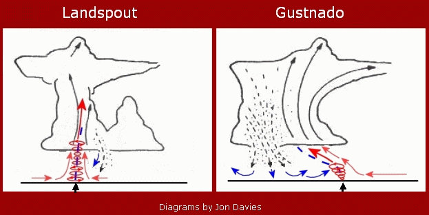
My analysis (previous blog post) of the setting for Sunday’s “gustnado” on 4/3/11 near Perry KS stirred up different reactions and opinions as to whether Sunday’s vortex actually was a “tornado” or not. Nature certainly defies categories made by man, and there are definite gray areas in classifying tornadoes and small-scale atmospheric vortices.
Sunday’s “gustnado” was not associated with a mesoscyclone. But a “landspout” (a non-supercell _tornado_ according to the AMS glossary) isn’t associated with a mesocyclone, either, and is considered a tornado because the vortex (along a nearly stationary or slow-moving boundary) extends well up into the cloud of the parent thunderstorm, with dust typically extending in a vertical column all the way to cloud base, often under a condensation funnel aloft. Gustnadoes always occur along thunderstorm gust fronts and are more shallow; the AMS glossary definition also categorizes them as “weak” and “short-lived”.
To my way of thinking, landspouts and gustnadoes are somewhat similar: They both develop from vertical stretching of an area of slow “spin” or vorticity along a boundary, tightening that into a stronger more well-defined vortex. More prolific landspout and gustnado days also feature a steep lapse rate near the ground that enhances vertical stretching as a result of strong surface heating, similar to days where multiple dust devils form over dirt fields from rapidly rising thermals.
The main difference between landspouts and gustnadoes seems to be the depth of the circulation, and the type of boundary they develop on. True landspouts (one type of non-mesocyclone tornado) tend to develop with thunderstorms on pre-existing stationary or slow-moving wind shift boundaries that are somewhat more “straight” in the vertical where the tightening circulation can extend to greater depths and last sometimes for tens of minutes. In contrast, gustnadoes always develop on gust fronts, typically faster moving boundaries that are more “curved/sloped” in the vertical, so that the tightening circulation can’t extend/stretch as deep and is more transient as the gust front moves/advances. See the diagram above that attempts to illustrate this difference.
But… what if there is a gust front that is not particularly fast-moving and maybe doesn’t have so much vertical slope? What if a circulation that develops and stretches on that gust front persists for more that a minute or two, lasting maybe 5 minutes or more? What if it occurs under a high cloud base (for example, above 2000 meters) where it is difficult to see how far the circulation extends upward? What if the circulation becomes rather intense (winds to EF1 intensity) and destroys a small farm building? Do we call this a “tornado”? What exactly is “shallow” and “not shallow”, according to the subjective AMS definition?
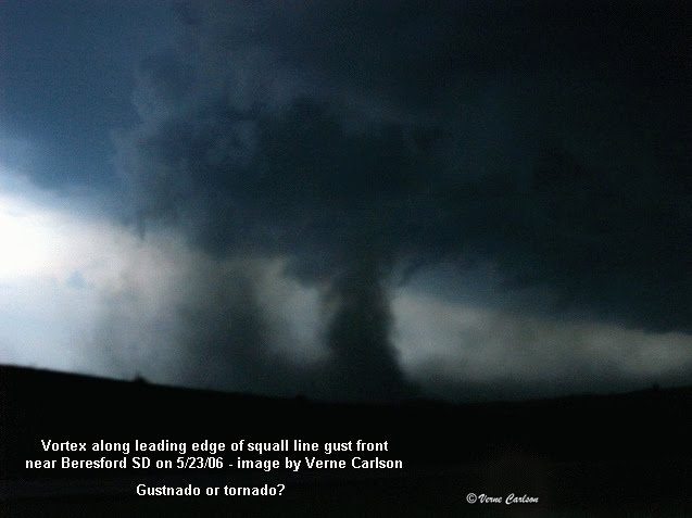
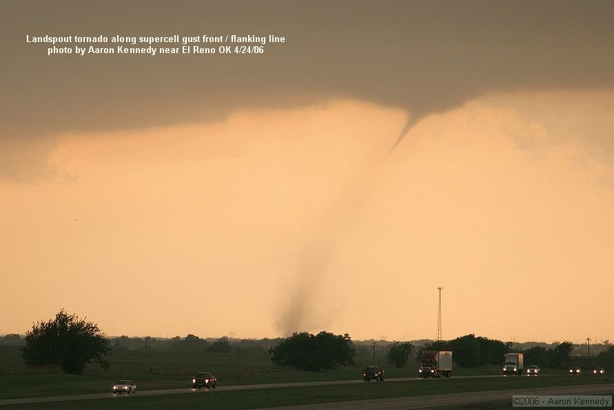
In 2006, on May 23rd, an “outbreak” of gustnadoes occured along the gust fronts associated with a squall line from southeast South Dakota to south-central Nebraska, with many photos taken by chasers. Dirt from some of these extended dramatically to cloud base, with cloud circulation sometimes visible in the shelf above them (see Verne Carlson’s photo above). NWS Sioux Falls called some of these vortices “tornadoes” in their local storm reports, while NWS offices in Nebraska did not (look up the SPC storm report log for 5/23/06). Here’s another situation the same year, April 24, 2006: A supercell storm produced a mesocyclone tornado near El Reno, Oklahoma. Then, a few minutes later, a non-mesocyclone tornado occurred south along the supercell gust front (see Aaron Kennedy’s photo above), which, with little temperature contrast, was barely moving and oriented more “vertical” than “sloped”. This tornado had a well-defined condensation funnel with dirt extending upward to it and the clear appearance of a “landspout”, even though it was technically on the storm’s gust front.
From the above, you can see where man-made definitions and categories fail us, and how difficult it is in some situations to decide how to categorize an atmospheric vortex associated with a thunderstorm. I’ll certainly admit that there may be a gray area about how to “categorize” Sunday’s vortex. The apparent processes involved with the location of the circulation on a rather fast-moving gust front argue for calling the vortex a gustnado. But the high cloud bases and inconclusive photography regarding how far the vortex really extended upward in the vertical also muddy the waters regarding classification. So there’s not a clearly definitive “answer”, and we may have to accept that.
With the vortex persisting for awhile and doing some damage, I can see the desire to call such a vortex a “tornado”, and I can’t completely argue against that. If that were the only criteria, several “gustnadoes” this author has seen and reported were really “tornadoes”. Had there been other tornadoes that captured the video spotlight on Sunday that were clearly supercell/mesocyclone in nature, I doubt that discussion would be so focused on this issue right now. For storm chasers, it is always more impressive to see what is categorized as a “tornado” than what NWS calls a “gustnado”.
Arguing about how to categorize Sunday’s vortex maybe misses the real point. Sometimes, there just aren’t exact clear-cut answers, and nature certainly doesn’t care what we call something. Perhaps we should just be aware and recognize that there are a wide variety of atmospheric vortices that we don’t fully understand or know how to categorize exactly. For research meteorologists, my wife calls this “job security” :-).
- Jon Davies 4/7/11