Big gustnado near Perry KS on 4/3/10 - not a tornado!
Originally published on davieswx.blogspot.com ↗
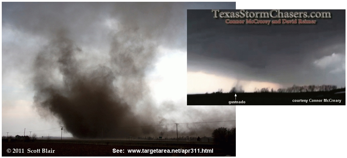
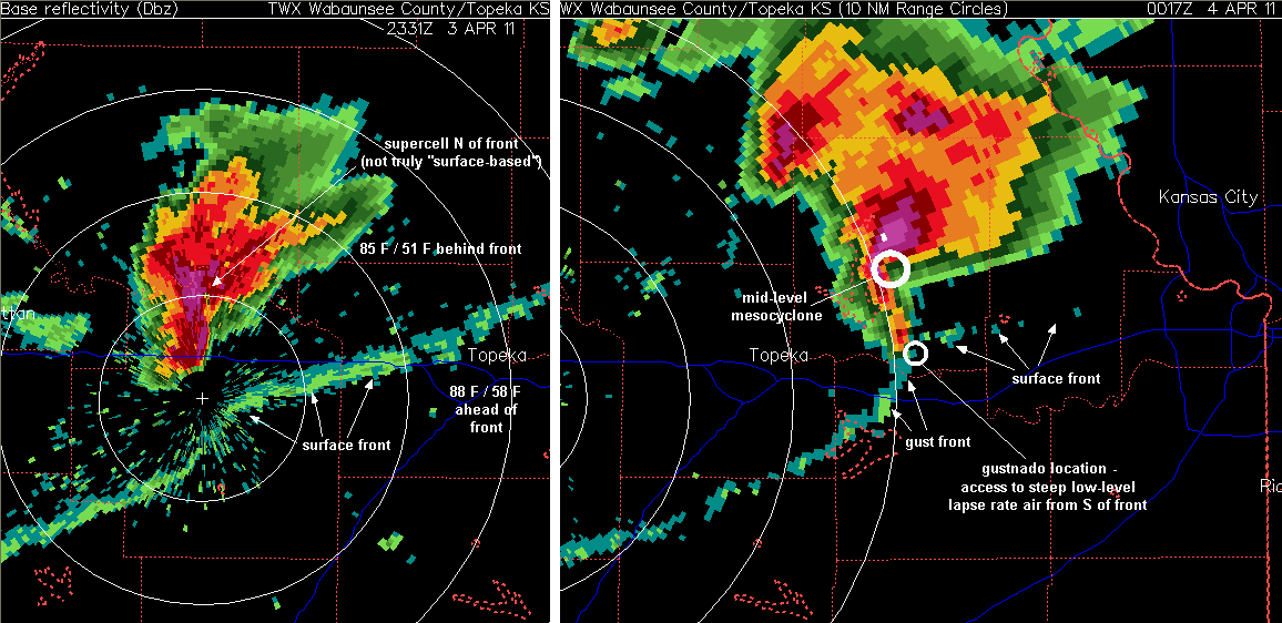
Sunday’s (4/3/10) storms over northeast KS featured a supercell that developed near Manhattan around 6 pm CDT (2300 UTC) north of a surface front. There was enough of a “cap” present that it took northward lift over the frontal surface to initate storms, even with temepratures near 90 F south of the front. As the Manhattan supercell passed N of Topeka and moved into Jefferson County northwest of Lawrence, the gust front extending south of the cell managed to tap very warm surface air south of the front, and a large well-organized gustnado (see photos above at top) formed near the intersection of the surface front and gustfront, east of Perry KS and well south of the supercell’s mid-level mesocyclone.
Scott Blair has excellent photos and analysis at www.targetarea.net/apr311.html, and NWS Topeka has a good discussion here.
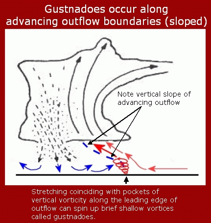
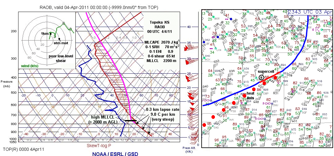
The large gustnado (a relatively shallow gust-front vortex compared to a tornado; see diagram above) probably would not have happened if the supercell gust front had not been able to access the steep low-level lapse rate air south of the surface front. On the radar images above (and a radar loop on the Topeka NWS site), you can see where the supercell was intially all north of the surface front. But as it moved east, the extreme south end along the gust front began to pull in true surface-based air near the frontal boundary-gust front intersection. Note that the observed sounding at Topeka prior to 7 pm CDT (0000 UTC, see skewT graphic above), before both the surface front and gust front passage, showed a very steep temperature drop off in the lowest 2-3 km, a lapse rate that meteorologists would call nearly “dry-adiabatic”. Such lapse rates are associated with dust devils and rapidly rising thermals on hot sunny days. In this case, it appears that this air helped with low-level stretching along the gust front near the boundary intersection area, creating a rather intense vortex on the gust front.
Note on the radar image above that the gustnado location was well removed from the mid-level mesocyclone area of the supercell to the north (the wide video image by Connor McCreary above also shows the shallow gustnado occuring along the flanking line/gust front). I’ve heard some people online claim this to be a “true” tornado, but real understanding of the cell’s geometry shows that it was _not_ a tornado, according to accepted definitions of gustnadoes. Gustnadoes can also often occur on days with LCL heights above 1600-2000m (like on 4/3/10), while true supercell tornadoes generally do not.
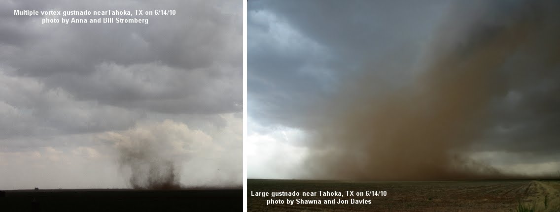
I’ve also heard some people claim Sunday’s gustnado was definitely a “tornado” because it had multiple vortices. Well… that means nothing; many gustnadoes have multiple vortices. See the last set of images above taken on a storm chase south of Lubbock last June 14th with my wife Shawna and also Anna and Bill Stromberg. Dozens of gustnadoes occured along a storm gust front that hot Texas day, including some with multiple vortices (see the first 6/14/10 photo by Anna and Bill). Some of the gustnadoes were relatively large, too, with organized rear inflow jets, as can be seen in the 6/14 images.
This particular gustnado on 4/3/10 was large enough and well-organized enough to do some damage, and has certainly gotten plenty of air play on TV in view of the lack of real tornadoes that day. Gust front vortices can be very interesting!
- Jon Davies 4/5/11